

New Century Electrical
Products
Water Condition Automatic Monitoring and Reporting System
- Overview
- Main Features
- Main Indicators
- Main functions
- Device Configuration
The automatic water condition monitoring and reporting system is suitable for river basins, hydraulic hubs, reservoirs, hydropower plants, etc. It utilizes advanced technologies such as telemetry, remote control, communication, computers, and modern communication to automatically complete real-time collection, transmission, and processing of data information such as water levels, flow rates, flow velocities, and flood conditions in measurement areas like river basins and reservoirs. Based on this, it makes water condition forecasts, publishes water condition information, and guides flood prevention in hydraulic engineering and hydropower generation, achieving scientific management of water conditions and optimal utilization of water resources.
The automatic water condition monitoring and reporting system includes various remote measurement terminal stations, network communication, water condition monitoring and reporting centers, and information centers of water authorities. It involves data on water conditions such as water levels and flow rates, water regulation, and meteorological management systems. Each type of data has specific attributes, and effective integration and comprehensive application of the data within the system are carried out through a database. The automatic water condition monitoring and reporting system mainly includes functions such as Geographic Information System (GIS), data communication and exchange, data processing, water condition forecasting, real-time data monitoring and alarms, image monitoring, human-computer interface, process line display, water condition information publishing, report management, and system management.
 Network diagram of the automatic water condition monitoring and reporting systemTypical project: Emergency water condition monitoring and reporting system for the construction period of the Tuxikou Reservoir in Sichuan in 2019Project overview: The Tuxikou Reservoir is located in Dukou Township, Xuanhan County, Dazhou City, Sichuan Province, primarily for flood prevention while also considering power generation. This reservoir is the first large-scale reservoir implemented in Dazhou City and is one of the 172 major water conservancy projects being accelerated nationwide. The maximum dam height of the project is 132 meters, with a total storage capacity of 160 million cubic meters and a power station installed capacity of 51,000 kilowatts, with an average annual power generation of 173 million kilowatt-hours. According to the "Implementation Plan for the Emergency Water Condition Monitoring and Reporting System during the Construction Period of the Tuxikou Reservoir Project in 2019," it is planned to build 2 automatic rainfall stations, 2 automatic rainfall water level stations, and 3 video stations upstream of the Tuxikou project, which, in conjunction with existing stations, can basically meet the flood prevention needs during the construction period of the Tuxikou Reservoir project.
1) Meet the requirements of the water resource monitoring data transmission protocol (SZY206-2016), basic technical conditions for water resource monitoring equipment (SL426-2008), hydrological monitoring data transmission protocol (SL651-2014), and hydrological remote terminal machine (SL 180-2015).
2) The system software adopts an integrated design of graphics, models, and libraries, provides standard data interfaces, and uses advanced models for flood forecasting, achieving high accuracy in predictions.
3) The system software adopts a hybrid model of C/S and B/S, building a data management center platform by integrating existing multi-source data, which is a digital platform for comprehensive management and sharing of meteorological data, rainfall information, disaster monitoring, and early warning.
4) The C/S software architecture facilitates the use of local area networks within departments such as water conservancy and meteorology, enabling data maintenance of the water situation database, spatial data visualization, interactive editing, and updating of large amounts of measured data.
5) The B/S software architecture solves the problem of remote application of spatial data, facilitating the publication of data, public service information queries, water situation information queries, and updates of mountain flood warning information.
6) The system can use various communication methods such as GPRS, 3G, 4G, and wireless data transmission stations, and has multiple data interfaces.
7) The system adopts a master/slave inquiry response working mode, which is flexible and not prone to data transmission errors.
8) The performance of the remote sensing station and relay station equipment is stable, with high accuracy, safety, and reliability, possessing lightning protection and electromagnetic interference resistance capabilities. It has self-recovery capabilities to support remote diagnosis, remote settings, and remote maintenance, and can operate stably for a long time under unattended outdoor conditions.
1. System Indicators
1) Operating Environment Parameters
Temperature: 5~40℃, allowable relative humidity: ≤90% (at 40℃)2) Measurement Error of Parameters: ≤±0.5% (depends on the selected collection sensor)
3) Electrical Quantity Collection Cycle: ≤1s
4) Non-Electrical Quantity Collection Cycle: ≤1s
5) Status and Alarm Point Collection Cycle: ≤500ms
6) Event Record Resolution Time: ≤2ms
7) Data Transmission Time from Telemetry Terminal to Real-Time Database: ≤1s
8) Response Time for System to Call New Screen: ≤1s
9) Dynamic Data Refresh Time on Displayed Screen: ≤1s
10) Time from Alarm or Incident Occurrence to Sound Notification on Screen: ≤2s
11) System Availability: ≥99.9%
12) The system meets the requirement to complete real-time data collection, processing, and forwarding within 5 minutes.
13) The error rate of the data transmission channel Pe meets the following indicator requirements:
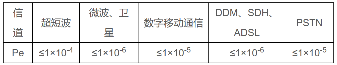
14) System Reliability
Under specified conditions and within the specified time, the monthly average smooth rate of system data collection should reach 95%, with the monthly average smooth rate of important control stations reaching over 98%. The completion rate of data processing should be greater than 95%. The error rate of data storage should not exceed 0.01%.
The smooth rate of data transmission through the network should reach over 99%.
The average time between failures (MTBF) should not be less than 20000 hours, in accordance with GB/T18185-2014.
2. Measurement Station Indicators
1) Environmental Parameters
Normal Operating Temperature: -30~60℃
Relative Humidity: ≤95% (at 40℃)
Protection Level: IP54 and above (moisture-proof, salt spray-proof, dust-proof, insect-proof)
2) Main Parameters
Rainfall: 0~999.9mm, can be recycled
Water Level: 0~4095cm (parallel 12-bit Gray code input)
DC Power Supply: 12V, allowable deviation: -10%~+20%
Power Consumption: Operating Current: ≤100mA (data collection and transmission state)
Static Monitoring Current: ≤2mA (self-reporting)
≤12mA (query-response type)Clock Accuracy: Error less than 4 seconds/day
Average Time Between Failures (MTBF): 50000 hours
1) Real-time data collection, processing, and record query of water and rainfall conditions. This includes various telemetry and remote signaling data sent or polled from each telemetry station, such as water level, rainfall, meteorological information, and station parameters.
2) Statistical analysis of the water condition system operation, including statistics on station water volume, water level, rainfall, and communication smoothness rate. Statistical analysis can be selected by station and time.
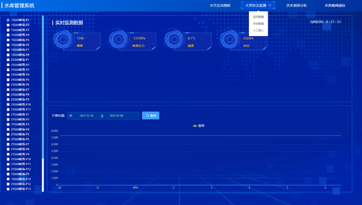
3) Comprehensive data monitoring of water conditions, monitoring the water level, flow, rainfall, meteorological information, etc., of various stations in the watershed. The central station monitoring system can dynamically display the system's processes, parameters, equipment conditions, etc., in the form of images, reports, and graphics.
4) For operational data, various special calculations can be performed, including maximum, minimum, average, deviation, cumulative values, and others. Various water condition reports, trend curves, and data graphs can be generated as needed.
5) The human-machine interface of the water condition system can fully graphically display water level process lines, rainfall bar charts, flow process lines, and rainfall flood correspondence diagrams.
6) Image monitoring of the water condition system. For the image monitoring needs of telemetry stations in rivers and lakes, it supports both infrared cameras and industrial camera image capture functions, as well as video monitoring through network video cameras.
7) Alarm function of the water condition system. An alarm signal will be issued when the operational data exceeds limits or when equipment detection is abnormal, guiding operational management personnel to handle it in a timely manner.
8) The water condition central station system can perform parameter settings and remote maintenance for telemetry terminals. Parameter settings for telemetry terminals include sampling time intervals, scheduled self-report intervals, main channels, backup channels, rainfall increment threshold, backup report number intervals, standard time, failure retransmission counts, and other parameter settings, supporting remote fault diagnosis and program downloads for telemetry terminals.
9) Data compilation, statistical information on all water level, rainfall, and flow stations in the watershed, including the following functions: hourly water level, rainfall, and flow statistics for multiple stations; daily water level, rainfall, and flow tables for multiple stations by month; daily water level, rainfall, and flow tables for a single station by year.
10) The water condition system supports GPRS/CDMA, short message communication methods, and ADSL internet transmission. It can send messages to designated personnel's Mobile via GSM SMS or through mobile APP software applications.
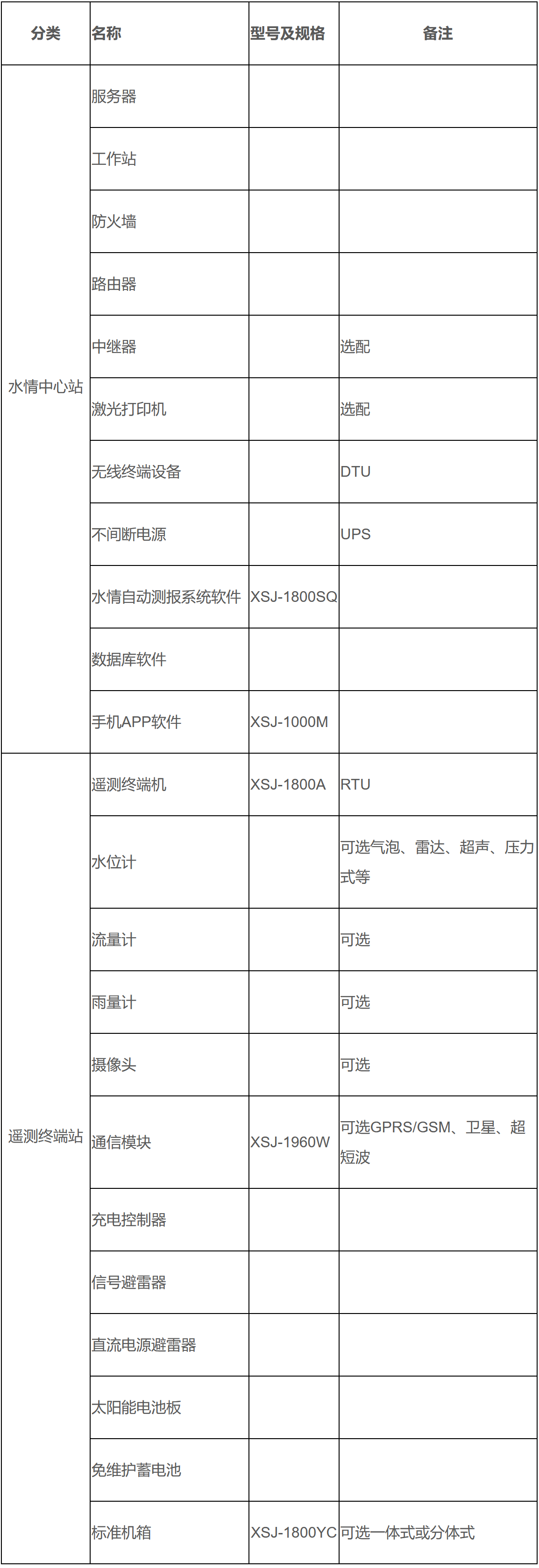
The water condition automatic monitoring and reporting system equipment will have different equipment configurations, installation requirements, and system integration application methods based on the project's construction or renovation scope, scale, technical requirements, and investment. The following is only a reference for the selection of water condition automatic monitoring and reporting system equipment.
Typical equipment configuration of the water condition automatic monitoring and reporting system
The next one:
©️ 2025 Chongqing New Century Electrical Co., Ltd. All Rights Reserved.
